Garthgynydd Hamlet
Garthgynyd Hamlet was in the north-west of the parish. It covered the eastern bank of the upper Taff-Bargoed River. The area is still very rural with the only urban community being the village of Bedlinog. In 1841 there were 14 farms of between 33 and 192 acres. 5 of these were owned by Lewis Edwards who lived at Bedlinog Farm, which was the only owner-occupied farm. As with all the northern Hamlets much of the land was common land part of Gelliager and Merthyr Common. The 1841 census recorded 24 houses in the hamlet, so on average 5 people lived in each house. These houses were generally farm houses, but there was a small community at Cwm y Felin with a Pub, a Blacksmiths and two other houses. There was no mention of the Mill which was once there.
The boundaries of the Hamlet in 1750 were given as “it begins where nant y garth goes to Bargod Taff then along the River Bargod till it comes to nant y feen then along nant y feen to Fynnon y Garn Ddu then directly to fose Tor Kenla then along the high way downwards to Pen ca Ivor?? then along the way westward to Funnon Cluide Trauska then to nant y garth opposite Craig vargod Meeting house then along nant y Garth to Bargod river aforesaid”.
The population was less in 1861 than it had been in 1801, but by 1871 it had more than trebled due to founding of Bedlinog village. The population in each sucessive census is shown in the table. By 1881 population was no longer recorded by hamlet as their function had all but disappeared.
| Census | Population | Houses |
| 1801 | 128 | |
| 1811 | 118 | 24 |
| 1821 | 121 | 21 |
| 1831 | 129 | 24 |
| 1841 | 127 | 23 |
| 1851 | 131 | 23 |
| 1861 | 125 | 23 |
| 1871 | 402 |
The farms as recorded in the 1841 tithe schedule are shown below. Most of the farms still appear on the modern OS map. The name Nant-y-ffin still appears on the map but now within the boundaries of the old parish of Merthyr Tydfil rather than Gelligaer. Tir y Colly is now Coly-uchaf, Colly isha is Coly-isaf, Bedlinog isha has disappeared under the village of Bedlinog. The names Bedlinog Farm, Blaenllwynau, Garth-gynydd, Lan-uchaf, Blaen-nant-wen, Tylaglas, Twyn-giden Farm, and Clawdd Trawscae all still appear on the OS map, although there is no farmhouse associated with the name Blaen-nant-wen. Lan isha is now called Pen-mount. Most farms in Gelligaer parish can be traced back to a survey of 1540 and some even earlier. Histories of these farms up to 1841 are shown on this site.
The tithe value has been converted to modern pounds/pence; it gives an indication of the relative values of the farms in 1841.
If the farm name is blue, clicking on it will display a History of the Farm from 1540 to 1840 as an A4 PDF (some browsers may not display the PDF) .
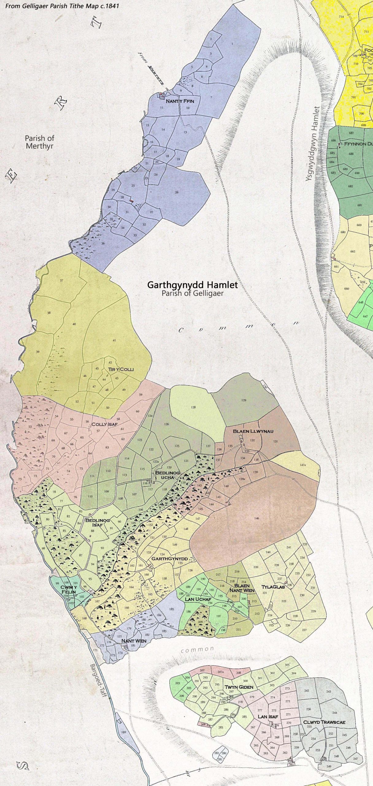
Click map to view
| Farm name | Acreage | Tithe value | Owner | Tenant |
| Nant y ffin | 192 | £8.05 | Sir Charles Morgan | William Richards |
| Tir y Colly | 186 | £8.05 | Marquess of Bute | Nicholas Waters |
| Colly isha | 108 | £5.95 | Sir Josiah John Guest | Thomas Williams |
| Bedlinog isha | 91 | £5.20 | Lewis Edwards | George Watson |
| Mill & land | 8 | £0.75 | Lewis Edwards | William Davies |
| Bedlinog | 120 | £8.55 | Lewis Edwards | self |
| Blaen Llwyne | 156 | £8.05 | Lord Dynevor | Thomas Llewelyn |
| Garthgynydd farm | 100 | £6.35 | Edmund Williams | William Lewis |
| Nant Wen | 41 | £2.70 | Capel Hanbury Leigh | Lewis Williams |
| Lan Ucha | 34 | £2.75 | Lewis Edwards | Lewis Richards |
| Blaen Nant Wen | 33 | £1.95 | Capel Hanbury Leigh | Lewis Richards |
| Tyleglas | 69 | £5.80 | Richard Edwards | Thomas Richards |
| Twyn Giden | 50 | £3.00 | Edmund Evans | William Walters |
| Cae Llwyd | 8 | £0.50 | Lord Dynevor | Edmund Evans |
| Lan Isha | 38 | £2.60 | Lewis Edwards | Edward Williams |
| (Clwyd)Trawscae | 63 | £4.20 | Capel Hanbury Leigh | David Lewis |